Capital Design Guidelines

G1 Site Planning and Urban Form

G1
Options

Site planning is the thoughtful and systematic organization of the physical environment to suit an intended use. At the urban design scale, this means the strategic and harmonious arrangement of infrastructure, streets, buildings, parks and public spaces to build a cohesive and distinguished Capital.

From the outset of design, it is important to fully understand the subject site and its surrounding context. Site planning exercises begin with a detailed inventory and analysis of key characteristics, such as geophysical conditions, heritage features, natural environment and urban context.

The objectives are efficient and responsible land use, preservation of regional and local character, and the achievement of well-functioning, pleasing and appropriate physical design. Projects must capitalize on inherent qualities to be a positive and coherent addition to the surrounding form, fabric and networks.

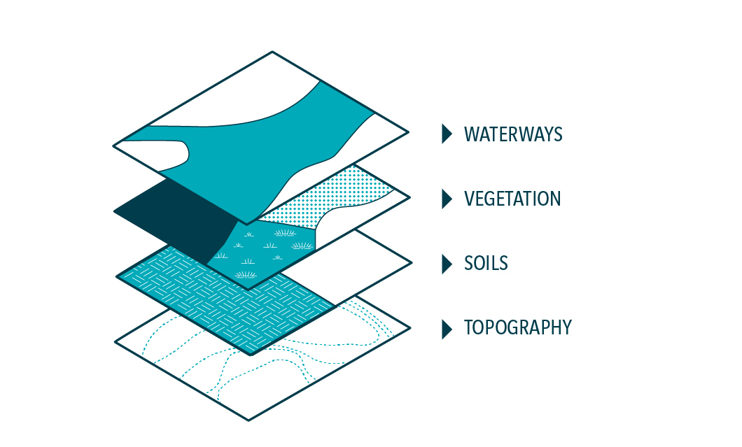
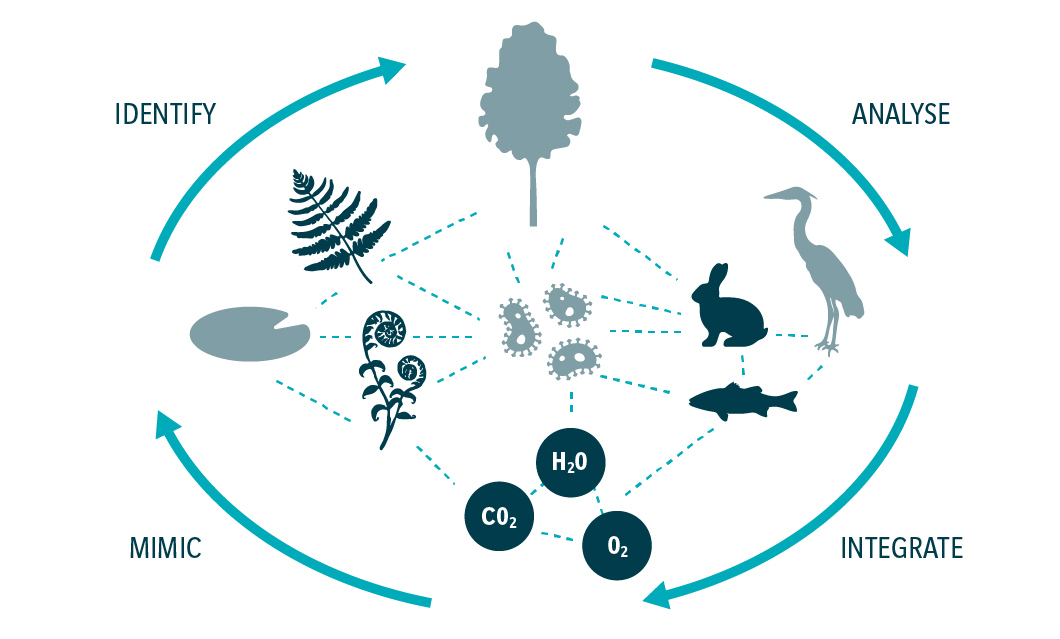
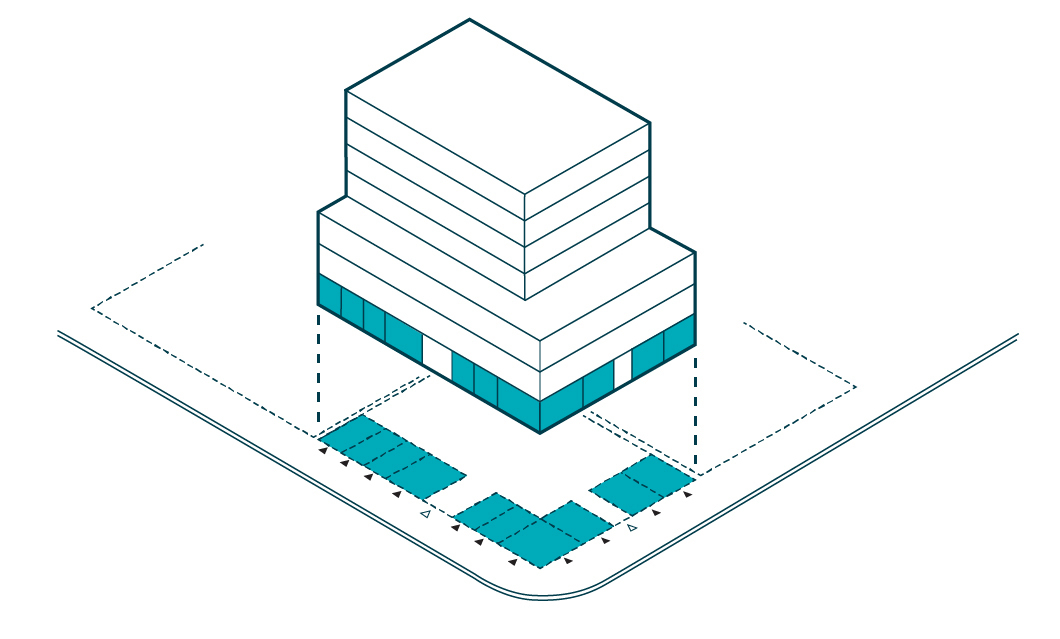
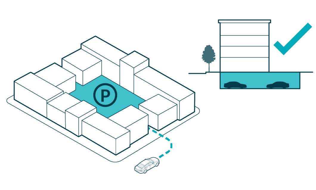
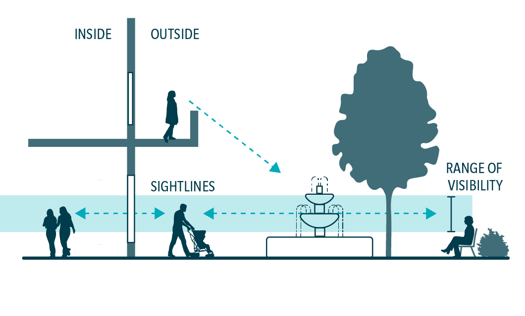
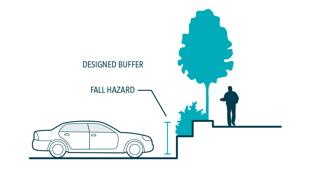
1.1 Site Context and Analysis

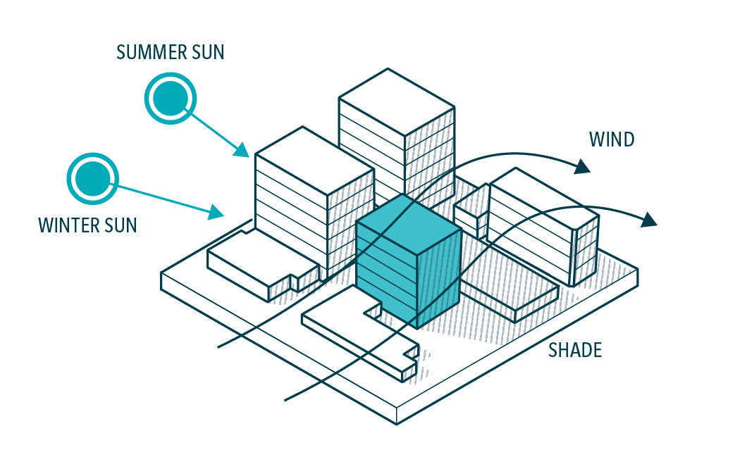
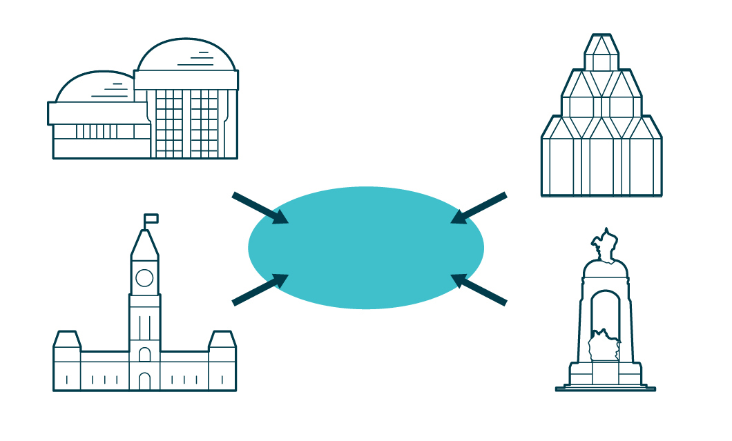
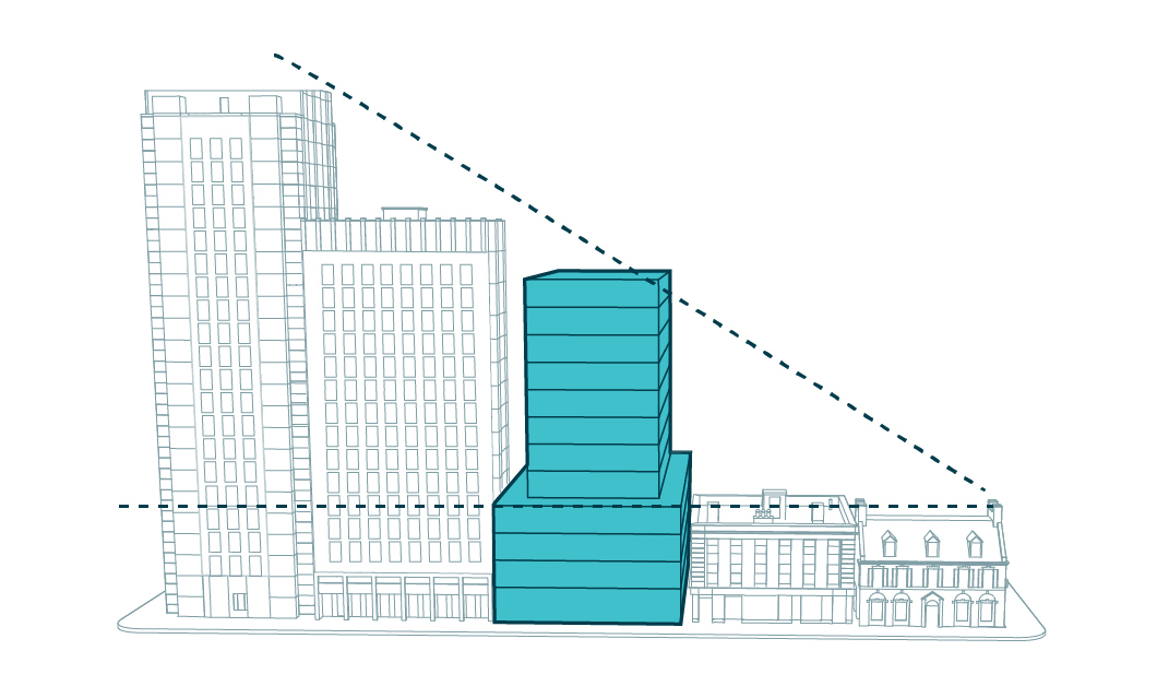
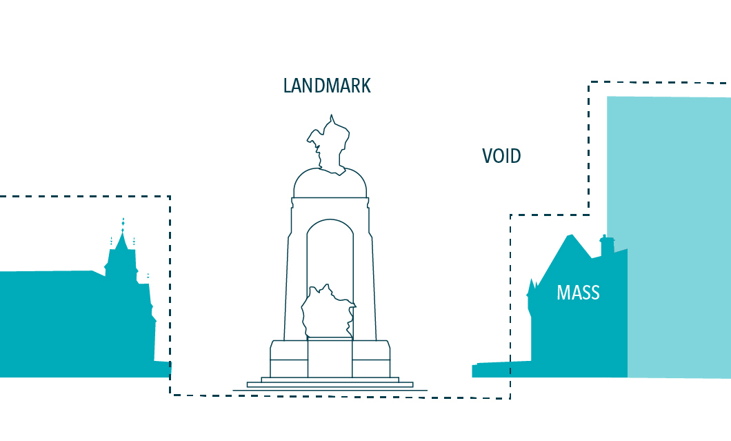
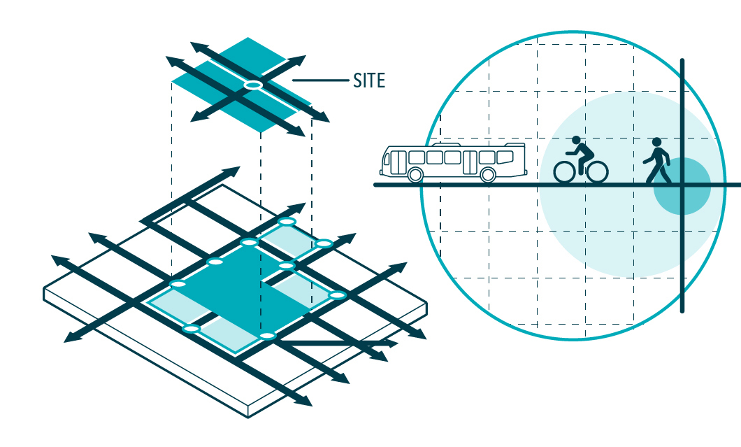
Each federal property or project is unique and must respond to its surroundings. Planning and design begin with analyzing and understanding a site’s key features, context and place within the broader Capital region.

Designers should complete an examination of the site’s existing context and surroundings, according to the prompts provided in this section, to inform the rest of the design process. The objectives are designs that are well-informed, responsive to their context, suitable to their function, and pleasing in their form.

  • 1.1.1

    Biophysical Assessment

    Inventory and assess biophysical features (e.g. topography, vegetation, waterways) to determine important attributes and character-defining features to be preserved or enhanced.

  • 1.1.2

    Built Environment

    Inventory and assess all existing buildings, structures, and infrastructure before the development of a site plan to identify what to conserve, modify, add to, or replace.

  • 1.1.3

    Context

    Arrange and design sites to suit both the existing surrounding context and building typologies (e.g. rural, urban, suburban) as well as the planned urban form.

  • 1.1.4

    Patterns and Form

    Study the prevailing pattern of urban form, fabric, street configuration and building placement. Arrange the design to contribute to a harmonious composition of parts and an intuitive hierarchy of elements and spaces.

  • 1.1.5

    Integration

    Determine the function of each part of a project and arrange them to suit their purpose and contribute to the purpose of others. Demonstrate how the project will enhance the site’s integration with its surroundings.

  • 1.1.6

    Climatic Conditions

    Respond to climatic conditions through choices such as orienting buildings and public spaces to maximize solar penetration in winter and shade in summer, and to avoid adverse microclimatic effects related to wind.

  • 1.1.7

    Important Sites

    Employ the highest planning and design standards to sites containing, or in proximity to, national symbols and landmarks.

  • 1.1.8

    Massing

    Ensure appropriate transitions in height, scale, proportion, form and spatial arrangement of surrounding development and adjacent sites.

  • 1.1.9

    Framing

    Orient the site and locate buildings and structures to frame and enhance important views of national symbols and significant landscapes. Ensure that these views are protected.

1.2 Natural and Cultural Heritage

The National Capital Region is situated on the ancestral lands of the Algonquin Anishinabeg Nation, in a spectacular setting at the confluence of three major rivers. The natural landscape of the Capital reflects the deep meaning and importance of natural heritage in Canada’s national identity, and the layers and patterns of human history and cultural exchange stretching back thousands of years.  

Cultural landscapes, heritage sites, and archaeological discoveries all contextualize the Capital’s course of history. Designers should analyze and draw inspiration from the site’s place and role within this history. The objectives are to carefully situate new projects within their historical context, showcase cultural narratives, and respect heritage attributes, all of which contribute to the distinctive places and cultural significance of the Capital. 

  • 1.2.1

    Natural Features

    Preserve, enhance, and showcase important natural heritage features (e.g. rivers, escarpments, hills and forests of the region).

  • 1.2.2

    Ecological Functions

    Integrate natural processes into the site design: preserve, rehabilitate and restore. Where a natural state cannot be maintained, identify opportunities to integrate and mimic natural processes.

  • 1.2.3

    Topography and Vegetation

    Conserve existing topography and natural native vegetation. Avoid clearing and regrading/levelling sites where topography contributes to a site’s experience.

  • 1.2.4

    Character Features

    Identify and retain notable site features that contribute to the unique sense of place (e.g. iconic railings, fences, lamp posts, benches).

  • 1.2.5

    Historical Inspiration

    Draw inspiration from the history, archaeology and cultural landscapes of the site and surrounding area to inform the site’s form and features.

  • 1.2.6

    Showcase

    Preserve and display archaeological discoveries, vestigial site features, cultural narratives, and past site uses.

  • 1.2.7

    Intervention

    Ensure that interventions respect and complement the heritage context. Avoid negatively altering or inadvertently impacting character-defining features.

  • 1.2.8

    Significant Trees

    Preserve notable trees as a living legacy and testament to the site’s history and character. Mature trees contribute to the Capital’s comfort, beauty, shading and forested character.

1.3 Site Layout

The capital realm is made up of diverse sites and locations: public, private, natural and urban. While their roles and uses vary, it is important that sites in the Capital are well laid out to achieve their purpose. The design of built and landscaped spaces is closely linked with user behaviour and requirements. The design of spaces begins with analyzing the needs of those who will use the space, and designs are more effective when user needs are understood.

The layout and design of spaces present suggestions of how the space is meant to be used: its level of privacy, how to travel through it, and where one can be comfortable in different conditions. The objective is an intuitive design that provides clear expectations to users of the form and function of a space.

  • 1.3.1

    Arrangement

    Configure and arrange important elements and destinations with logical entrance and exit points and clear lines of sight and travel.

  • 1.3.2

    Public Realm

    Make clear which exterior spaces are part of the public realm through amenities and design features appropriate to the location and its role (e.g. furnishings, public amenities, and signage).

  • 1.3.3

    Private Areas

    Identify which areas are private, restricted or utilitarian spaces. Locate them discreetly and provide clear identification of their role through placement, circulation patterns and design features (e.g. fences, gates, screens and changes in materiality).

  • 1.3.4

    Anchors

    Locate commonly used public features in prominent and easily accessible locations.

  • 1.3.5

    Edges

    Design property edges and boundaries to provide safe, attractive and legible transitions to the character and patterns of use of adjacent streets and sites.

  • 1.3.6

    Building Orientation

    Orient buildings to face roads and frame public spaces, contribute to adjacent spaces and improve pedestrian safety and landscape amenities within the public realm.

  • 1.3.7

    Active Frontages

    Provide active building frontages that present safe, animated and distinctive faces to adjacent streets and properties.

  • 1.3.8

    Vehicular Access

    Arrange vehicular circulation, arrival and drop-off zones to prioritize public spaces and minimize vehicular impacts. Limit the number of driveways that cross sidewalks to preserve pedestrian priority.

  • 1.3.9

    Parking

    Minimize and discreetly locate parking with clear travel routes to entrances and destinations. Avoid placing parking between buildings and adjacent streets or in locations that will discourage pedestrian travel.

1.4 Safety and Security

The Capital is the seat of government and, by extension, serves as a reflection of Canada’s democratic values. Fair and transparent governance requires public access to federal institutions and public spaces that permit citizens to gather, discuss and celebrate topics of national importance.

Site planning and urban design involves analyzing and understanding public and national security needs and balancing them with the creation of welcoming and pleasing spaces. The objective is for the design of institutions to permit visitors and residents alike to navigate the Capital, enjoy the city, and engage with their government. By integrating necessary safety and security installations, while ensuring that these features blend in with their surroundings, designing for safety and security will not unnecessarily impede public uses or otherwise clutter, or detract from, the public realm.

  • 1.4.1

    Visual Permeability

    Provide visual permeability into public spaces and federal buildings, to facilitate spatial orientation and perceived safety.

  • 1.4.2

    Natural Deterrents

    Deter mischief and crime by promoting frequent public use and visitation to foster a safe and welcoming atmosphere. Employ soft approaches to security (e.g. lighting, music and ambiance) before hardened installations.

  • 1.4.3

    Circulation and Egress

    Provide safe and attractive pedestrian linkages with convenient access to and from pathways, sidewalks or public spaces. Avoid dead-ends and enclosed spaces.

  • 1.4.4

    Hazards

    Identify and mitigate risks to public safety through thoughtfully integrated site design and detailing solutions.

  • 1.4.5

    Design Integration

    Integrate security devices into the site design so that they reflect and contribute to the site’s aesthetics and character.

  • 1.4.6

    Perimeters and Barriers

    Where a controlled perimeter is required, employ fences, walls and barriers that present a pleasing and finely detailed face to the adjacent public realm.

  • 1.4.7

    Screening Facilities

    Where controlled access and visitor screening are required, design facilities as prominent doors and entries with attention to placement, detail, materiality and surrounding context. Integrate facilities into building envelopes or site features.

  • 1.4.8

    Surveillance

    Integrate surveillance features discreetly into their surroundings so as not to visually dominate the environment.

1.5 Circulation and Mobility

Circulation and mobility networks have shaped the Capital of today. From travel on the Ottawa River, and the construction of the Rideau Canal, to railway relocations, the federal parkway network, and the Capital Pathways, the ways that people move through the Capital help to define the experience it offers.

Designers should analyze existing and potential connections to mobility networks (e.g. pedestrian, cyclist, transit, vehicular, marine) to inform how to connect sites. The objectives are to ensure that sites are accessible and that the experience of travelling through the Capital contributes to its image and user experience.

  • 1.5.1

    User Experience

    Promote a people-first approach to create pleasing, safe and convenient routes and connections. Accommodate layered modes of mobility, both present and future.

  • 1.5.2

    Seamless Networks

    Ensure sites are well connected to, and participating in, surrounding mobility networks. Avoid the creation of impermeable blocks and continue the pattern of mobility networks through sites.

  • 1.5.3

    Desire Lines

    Arrange paths of travel to and through sites to accommodate the anticipated behaviour of users. Avoid compensating for unintuitive design with signage and obstacles.

  • 1.5.4

    Integration

    Design thoroughfares to connect to and reinforce places and destinations through material choice, alignment, views and landscape integration.

  • 1.5.5

    Space

    Provide transportation infrastructure in compact, efficient layouts. Avoid expansive roadway configurations, slip lanes and on-ramps that increase vehicle speeds and fragment spaces.

  • 1.5.6

    Human Scale

    Treat roadway rights of way as public spaces. Make streets lively, human-scaled places to linger and enjoy and not simply pass through.

  • 1.5.7

    User Safety

    Recognize that users will make mistakes. Design to avoid conflict, injury and collisions, and to reduce their severity when they do occur.

  • 1.5.8

    Clarity

    Where conflict or friction may occur between different modes, provide design cues that clarify who has priority. Employ infrastructure to direct appropriate user behaviour while protecting vulnerable users.

  • 1.5.9

    Ancillary Infrastructure

    Integrate ancillary transportation infrastructure discreetly into the streetscape design. Limit visual clutter to provide clarity and legibility within the landscape.